njg6tag
NSG 9 badge

Signals Intelligence


During II./NJG 6's two deployments to Northern Italy, Anglo-American Field Signals Units were aware of the activities of its aircraft from the traffic associated with their Y-Verfahren fighter control system (known to the Allies as "Benito").

The results of this monitoring were plotted on to the German fighter grid.

On the version below, red blocks indicate the grid squares where "Benito" traffic was heard in May 1944, the yellow ones show where the signals were picked up during June. While the May signals emanated from within the Gruppe's asisgned patrol area, those in June are a long way north of where operations were being flown.

netz


Sources: I based this graphic on a monochrome photocopy of an ANR pilot's map provided by Ferdinando D'Amico, adding the colour with Photoshop™.

The original Signals Intelligence map survives only as a rather faint pencil drawing, recorded on microfilm, in the British National Archives.


navtagt

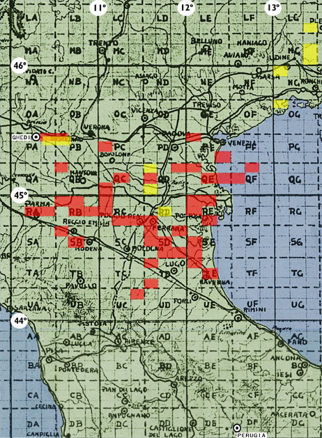
ABOUT THIS MAP

The Luftwaffe fighter grid for Italy. It was based on lines of latitude and longitude and used a system of squares, each with a two-letter code.

Each square was subdivided into nine which were numbered in sequence from left to right, working down the rows.

While in Italy, II./NJG 6 was based at Ghedi which is in PA 3. Their forward base of Perugia was in DF 7.

Note: this grid was different from the one used by NSG 9 for night ground attack operations.


homelink top